


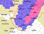
CHARLESTON, W.Va. – It’s shaping up to be a snowy and chilly New Year’s celebration around West Virginia, with a clipper system bringing winter weather into the Mountain State over the next 24 hours.
Up to ten inches of snow is expected in higher elevations, while accumulations in the lowlands could reach four inches.
“This is going to bring some accumulating snowfall, pretty much area-wide, and the heaviest snowfall accumulations will be across the mountainous counties,” National Weather Service meteorologist Simone Lewis told MetroNews.
That weather system could affect New Year’s festivities across the state. The worst conditions are expected to arrive right around the same time that 2026 does in the Eastern time zone.
“The main thing to keep in mind is that the period of greatest accumulating snowfall is actually expected on either side of midnight,” Lewis said.
Drivers will want to be aware of holiday traffic, but also because of the weather. Road hazards are expected to continue into Thursday with the combination of precipitation and low temperatures.
“If folks are planning to head out for New Year’s festivities, they’re going to want to keep this in mind—that hazardous travel conditions may develop,” Lewis said.
Forecasts show that despite the snow coming, there is light at the end of the tunnel. Warmer temperatures appear to be on the way, and even some of the areas that receive heavy snowfall could see the melt start by the end of the week.
“We are actually going to be looking at a gradual warming trend after Thursday, so once we start getting into Friday and the weekend, many locations are going to be rising above freezing, and this does include some mountainous locations also,” Lewis said.
Snow is expected to continue into Thursday morning, with low temperatures carrying on through the day.