


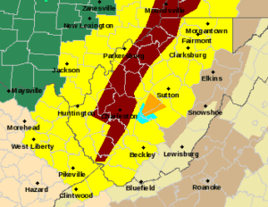
CHARLESTON, W.Va. — The National Weather Service had at least 10 counties under flash flood warnings at 6 p.m. Thursday with heavy rain continuing to move in from the south.
There were a number of severe thunderstorm warnings that were filled with lots of thunder and lightning and heavy rain.
High water was reported on a section of the interstate near the state capitol in Charleston. There were flooding warnings also issued for central West Virginia counties and the state’s northern panhandle.
The National Weather Service previously placed 39 West Virginia counties under a tornado watch until 9 p.m. Thursday but meteorologists said the heavy rain cut down on the wind threat.
The counties under the tornado watch include: Barbour, Boone, Braxton, Brooke, Cabell, Calhoun, Clay, Doddridge, Fayette, Gilmer, Hancock, Harrison, Jackson, Kanawha, Lewis, Lincoln, Logan, Marion, Marshall, Mason, McDowell, Mingo, Monongalia, Nicholas, Ohio, Pleasants, Preston, Putnam, Raleigh, Ritchie, Roane, Taylor, Tyler, Upshur, Wayne, Webster, Wetzel, Wirt and Wood counties.
West Virginia set a one day tornado record in the April 2 storm event.
The National Weather has confirmed 10 tornadoes from that day.
There has been little severe weather in the state as of 4:30 p.m. Thursday. There was a severe thunderstorm warning for parts of Mingo and Logan counties for until 4:15 p.m.